


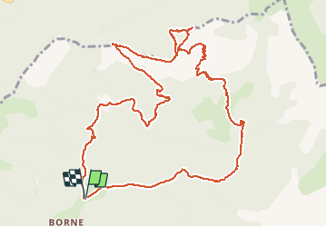
Montagne de Belle Motte

ajd26
User

Length
14.8 km

Max alt
1938 m

Uphill gradient
1050 m
Km-Effort
29 km

Min alt
926 m

Downhill gradient
1049 m
Boucle
Yes
Creation date :
2019-08-22 07:02:24.0
Updated on :
2019-08-22 17:31:03.116
6h15
Difficulty : Medium

FREE GPS app for hiking
 SityTrail
IGN / Geographical institutes
SityTrail Plus
The world is yours!
About
Trail Walking of 14.8 km to be discovered at Auvergne-Rhône-Alpes, Drôme, Glandage. This trail is proposed by ajd26.
Description
22/08/2019 depuis Borne, montagne de Belle Motte, col du plat, le Plainie. Très jolis panoramas sur la crête de Belle Motte
Positioning
Country:
France
Region :
Auvergne-Rhône-Alpes
Department/Province :
Drôme
Municipality :
Glandage
Location:
Unknown
Start:(Dec)
Start:(UTM)
705260 ; 4954852 (31T) N.
Comments