Trail Walking Lac-Supérieur - Wikiloc - LE CENTENAIRE - Photo

Wikiloc - LE CENTENAIRE

 Alizée.pee
Alizée.pee

User GUIDE

© OpenStreetMap contributors
Length
Length
13.6 km
Max alt
Max alt
737 m
Uphill gradient
Uphill gradient
561 m
Km-Effort
Km-Effort  
21 km
Min alt
Min alt
327 m
Downhill gradient
Downhill gradient
563 m
Boucle
Boucle
Yes
Creation date :
2019-08-23 13:17:49.254
Updated on :
2019-08-23 13:20:09.319

(0 Reviews)

Walking
Walking
4h21
Difficulty : Very difficult

Scan this QR Code to open this trail in the SityTrail application

FREE GPS app for hiking

Logo SityTrail SityTrail

IGN / Geographical institutes

Download SityTrail from the App Store Download SityTrail from Google Play

Logo SityTrail SityTrail Plus

The world is yours!

Download SityTrail from the App Store Download SityTrail from Google Play Download SityTrail on Huawei AppGallery

About

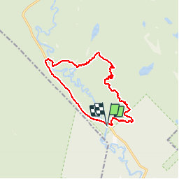
Trail Walking of 13.6 km to be discovered at Quebec, Les Laurentides, Lac-Supérieur. This trail is proposed by Alizée.pee.

Description

Magnifique chemin dans la forêt qui est encore plus belle lors de la coloration. La randonnée offre plusieurs points de vue de la vallée et de la rivière du Diable. Le sentier est néanmoins un peu accidenté, il faut donc être  prudent ! La fin de cette randonnée est assez reposante.

Elevation profile

Positioning

Country:
Canada
Region :
Quebec
Department/Province :
Les Laurentides
Municipality :
Lac-Supérieur
Location:
Unknown
Start:(UTM)
538183 ; 5122988 (18T) N.


Close
My subscriptions