Trail Walking Unknown - Wikiloc - Sentier du Col Wilcox - Photo

Wikiloc - Sentier du Col Wilcox

 Alizée.pee
Alizée.pee

User GUIDE

© OpenStreetMap contributors
Length
Length
10.7 km
Max alt
Max alt
2423 m
Uphill gradient
Uphill gradient
475 m
Km-Effort
Km-Effort  
17 km
Min alt
Min alt
2022 m
Downhill gradient
Downhill gradient
475 m
Boucle
Boucle
Yes
Creation date :
2019-08-23 13:57:11.926
Updated on :
2019-08-23 13:59:16.066

(0 Reviews)

Walking
Walking
3h30
Difficulty : Difficult

Scan this QR Code to open this trail in the SityTrail application

FREE GPS app for hiking

Logo SityTrail SityTrail

IGN / Geographical institutes

Download SityTrail from the App Store Download SityTrail from Google Play

Logo SityTrail SityTrail World

The world is yours!

Download SityTrail from the App Store Download SityTrail from Google Play Download SityTrail on Huawei AppGallery

About

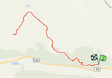
Trail Walking of 10.7 km to be discovered at Alberta, Improvement District No. 12. This trail is proposed by Alizée.pee.

Description

Le col Wilcox se situe en face du glacier Athabasca. Il n'est pas inhabituel de voir de la neige en juin et juillet, ne soyez pas étonné. Le sentier est assez escarpé et permet de profiter de panoramas magnifiques. Ce sentier est assez populaire !

Elevation profile

Positioning

Country:
Canada
Region :
Alberta
Department/Province :
Improvement District No. 12
Municipality :
Unknown
Location:
Unknown
Start:(UTM)
487966 ; 5785348 (11U) N.

Trails nearby

Trail Walking  - Wilcox Pass 2376 m - Photo
Walking
GOHIER

Walking

, Alberta, Improvement District No. 12, Canada
7.8 km | 12.7 km-effort
3h 24min
Yes
Trail Walking  - Parker Ridge - Photo
Walking
GOHIER

Walking

, Alberta, Improvement District No. 9, Canada
11.3 km | 16.7 km-effort
2h 39min
No
Trail Car  - Attabacca à Lake Louise - Photo
Car
GOHIER

Car

, Alberta, Improvement District No. 12, Canada
156 km | 186 km-effort
6h 16min
No


Close
My subscriptions