


bois d Aix neness

Christian Demoulib
User
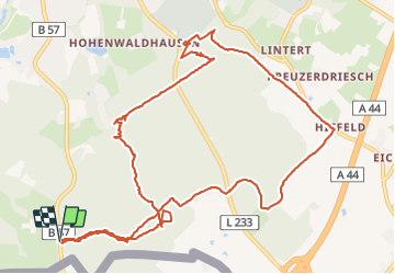

Length
12.8 km
Boucle
Yes
Creation date :
2019-08-23 11:28:33.768
Updated on :
2019-08-23 13:57:52.097
2h28
Difficulty : Very easy

FREE GPS app for hiking
 SityTrail
IGN / Geographical institutes
SityTrail Plus
The world is yours!
About
Trail Walking of 12.8 km to be discovered at North Rhine-Westphalia, Städteregion Aachen, Aachen. This trail is proposed by Christian Demoulib.
Positioning
Country:
Germany
Region :
North Rhine-Westphalia
Department/Province :
Städteregion Aachen
Municipality :
Aachen
Location:
Aachen-Mitte
Start:(Dec)
Start:(UTM)
294616 ; 5623246 (32U) N.
Comments