


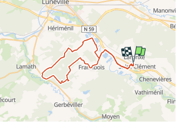
sortie VTT du 23082019 Xermamenil Etang de la reine

fabwin
User GUIDE


2h02
Difficulty : Easy

FREE GPS app for hiking
 SityTrail
IGN / Geographical institutes
SityTrail Plus
The world is yours!
About
Trail Mountain bike of 32 km to be discovered at Grand Est, Meurthe-et-Moselle, Saint-Clément. This trail is proposed by fabwin.
Description
Belle sortie avec Séb et Maxime.
Cela fait plaisir de revoir Maxime sur les pédales.
Un beau parcours assez varié, avec un chouette single en légère descente.
Il faut en profiter car bientôt …
3 chevreuils, un bel étang, un temps idéal.
Mon genou semble bien aller et je n'ai pas eu de douleur, mais à voir avec le temps.
Photos


Positioning
Comments