


mercurey - rully - champ de cesar

XavierFaidix
User
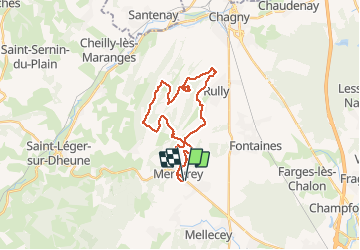

Length
25 km

Max alt
417 m

Uphill gradient
667 m
Km-Effort
34 km

Min alt
228 m

Downhill gradient
664 m
Boucle
Yes
Creation date :
2019-08-22 11:57:40.726
Updated on :
2019-08-24 06:17:50.756
2h50
Difficulty : Medium

FREE GPS app for hiking
 SityTrail
IGN / Geographical institutes
SityTrail Plus
The world is yours!
About
Trail Mountain bike of 25 km to be discovered at Bourgogne-Franche-Comté, Saône-et-Loire, Mercurey. This trail is proposed by XavierFaidix.
Positioning
Country:
France
Region :
Bourgogne-Franche-Comté
Department/Province :
Saône-et-Loire
Municipality :
Mercurey
Location:
Bourgneuf-Val-d'Or
Start:(Dec)
Start:(UTM)
631324 ; 5188092 (31T) N.
Comments