


Valvigniere 2

JeanPierreNancy
User
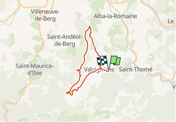

Length
24 km

Max alt
500 m

Uphill gradient
523 m
Km-Effort
31 km

Min alt
152 m

Downhill gradient
525 m
Boucle
Yes
Creation date :
2019-08-24 06:59:58.865
Updated on :
2019-08-24 09:21:53.786
2h19
Difficulty : Medium

FREE GPS app for hiking
 SityTrail
IGN / Geographical institutes
SityTrail Plus
The world is yours!
About
Trail Mountain bike of 24 km to be discovered at Auvergne-Rhône-Alpes, Ardèche, Valvignères. This trail is proposed by JeanPierreNancy.
Positioning
Country:
France
Region :
Auvergne-Rhône-Alpes
Department/Province :
Ardèche
Municipality :
Valvignères
Location:
Unknown
Start:(Dec)
Start:(UTM)
626301 ; 4928439 (31T) N.
Comments