Trail Mountain bike Saint-Omer - VTT avec Jeanne et Arthur  - Photo

VTT avec Jeanne et Arthur

© OpenStreetMap contributors
Length
Length
25 km
Max alt
Max alt
121 m
Uphill gradient
Uphill gradient
273 m
Km-Effort
Km-Effort  
29 km
Min alt
Min alt
10 m
Downhill gradient
Downhill gradient
273 m
Boucle
Boucle
Yes
Creation date :
2014-12-10 00:00:00.0
Updated on :
2014-12-10 00:00:00.0

(0 Reviews)

Mountain bike
Mountain bike
2h41
Difficulty : Very easy

Scan this QR Code to open this trail in the SityTrail application

FREE GPS app for hiking

Logo SityTrail SityTrail

IGN / Geographical institutes

Download SityTrail from the App Store Download SityTrail from Google Play

Logo SityTrail SityTrail World

The world is yours!

Download SityTrail from the App Store Download SityTrail from Google Play Download SityTrail on Huawei AppGallery

About

Trail Mountain bike of 25 km to be discovered at Hauts-de-France, Pas-de-Calais, Saint-Omer. This trail is proposed by samuel62380.

Elevation profile

Positioning

Country:
France
Region :
Hauts-de-France
Department/Province :
Pas-de-Calais
Municipality :
Saint-Omer
Location:
Unknown
Start:(UTM)
447223 ; 5621770 (31U) N.

Trails nearby

Trail Walking Clairmarais - Clairmarai - Photo
Walking
yves62410

Walking

Difficult
(1)
Clairmarais, Hauts-de-France, Pas-de-Calais, France
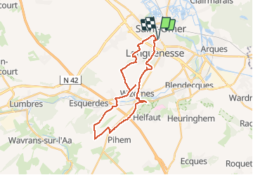
19.6 km | 21 km-effort
5h 8min
No
Trail Walking Nieurlet - Circuit de Booneghem -Nieurlet - Photo
Walking
tracegps

Walking

Medium
(1)
Nieurlet, Hauts-de-France, Nord, France
9.6 km | 10.1 km-effort
2h 30min
Yes
Trail Walking Tilques - Des Cressonnières au Marais  - Tilques - Photo
Walking
tracegps

Walking

Medium
(1)
Tilques, Hauts-de-France, Pas-de-Calais, France
10.7 km | 11.4 km-effort
2h 30min
Yes
Trail sport Clairmarais - À la découverte du marais audomarois - Photo
sport
tenace

sport

Very easy
(1)
Clairmarais, Hauts-de-France, Pas-de-Calais, France
6.8 km | 7.2 km-effort
Unknown
Yes
Trail On foot Clairmarais - activity_1282864488 - Photo
On foot
GUIDE
Peter.vdbergh

On foot

Medium
Clairmarais, Hauts-de-France, Pas-de-Calais, France
14.9 km | 16.1 km-effort
3h 59min
Yes
Trail Walking Nieurlet - Circuit de Booneghem - Photo
Walking

Walking

Very easy
Nieurlet, Hauts-de-France, Nord, France
8.6 km | 9.1 km-effort
Unknown
Yes
Trail Walking Clairmarais - copie - Photo
Walking
Bernard.voyageur

Walking

Easy
Clairmarais, Hauts-de-France, Pas-de-Calais, France
8.1 km | 8.5 km-effort
2h 4min
Yes
Trail Walking Clairmarais - Clairmarais - Photo
Walking
Greg813

Walking

Medium
Clairmarais, Hauts-de-France, Pas-de-Calais, France
24 km | 26 km-effort
5h 0min
Yes
Trail Canoe - kayak Tilques - canoé sur le Landsberg à Tilques - Photo
Canoe - kayak
lepompi

Canoe - kayak

Very easy
Tilques, Hauts-de-France, Pas-de-Calais, France
8 km | 8.3 km-effort
2h 0min
Yes


Close
My subscriptions