


Cilaos cascade bras rouge

YCDBSOYA
User
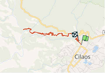

Length
7 km

Max alt
1209 m

Uphill gradient
404 m
Km-Effort
12.3 km

Min alt
904 m

Downhill gradient
402 m
Boucle
Yes
Creation date :
2019-08-25 05:15:44.0
Updated on :
2019-08-25 09:07:18.665
3h38
Difficulty : Medium

FREE GPS app for hiking
 SityTrail
IGN / Geographical institutes
SityTrail Plus
The world is yours!
About
Trail Walking of 7 km to be discovered at Réunion, Unknown, Cilaos. This trail is proposed by YCDBSOYA.
Description
Descente et retour de la cascade de bras rouge
Positioning
Country:
France
Region :
Réunion
Department/Province :
Unknown
Municipality :
Cilaos
Location:
Unknown
Start:(Dec)
Start:(UTM)
341338 ; 7662400 (40K) S.
Comments