


Glen Tannard

aldaus
User
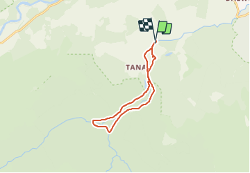

Length
8.2 km

Max alt
222 m

Uphill gradient
86 m
Km-Effort
9.4 km

Min alt
159 m

Downhill gradient
83 m
Boucle
Yes
Creation date :
2019-08-25 12:19:53.862
Updated on :
2019-08-25 20:11:02.344
2h25
Difficulty : Very easy

FREE GPS app for hiking
 SityTrail
IGN / Geographical institutes
SityTrail Plus
The world is yours!
About
Trail Walking of 8.2 km to be discovered at Scotland, Aberdeenshire. This trail is proposed by aldaus.
Positioning
Country:
United Kingdom
Region :
Scotland
Department/Province :
Aberdeenshire
Municipality :
Aboyne
Location:
Unknown
Start:(Dec)
Start:(UTM)
508558 ; 6323658 (30V) N.
Comments