


seign1

bubu90
User
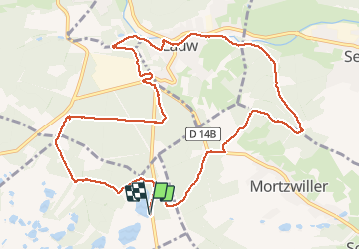

Length
12.4 km

Max alt
449 m

Uphill gradient
148 m
Km-Effort
14.3 km

Min alt
371 m

Downhill gradient
148 m
Boucle
Yes
Creation date :
2019-08-14 11:46:51.951
Updated on :
2019-08-26 08:51:29.794
3h01
Difficulty : Very easy

FREE GPS app for hiking
 SityTrail
IGN / Geographical institutes
SityTrail Plus
The world is yours!
About
Trail Walking of 12.4 km to be discovered at Bourgogne-Franche-Comté, Territoire-de-Belfort, Leval. This trail is proposed by bubu90.
Positioning
Country:
France
Region :
Bourgogne-Franche-Comté
Department/Province :
Territoire-de-Belfort
Municipality :
Leval
Location:
Unknown
Start:(Dec)
Start:(UTM)
351139 ; 5288948 (32T) N.
Comments