


Correns fait

harydh
User GUIDE
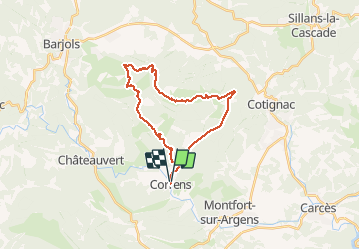

Length
26 km

Max alt
569 m

Uphill gradient
560 m
Km-Effort
34 km

Min alt
162 m

Downhill gradient
561 m
Boucle
Yes
Creation date :
2019-08-26 07:02:19.761
Updated on :
2019-08-26 09:58:52.826
2h55
Difficulty : Medium

FREE GPS app for hiking
 SityTrail
IGN / Geographical institutes
SityTrail Plus
The world is yours!
About
Trail Mountain bike of 26 km to be discovered at Provence-Alpes-Côte d'Azur, Var, Correns. This trail is proposed by harydh.
Photos


30 photos in total. Please click on a photo to see them all in the gallery.
Positioning
Country:
France
Region :
Provence-Alpes-Côte d'Azur
Department/Province :
Var
Municipality :
Correns
Location:
Unknown
Start:(Dec)
Start:(UTM)
263998 ; 4819282 (32T) N.
Comments