Trail Walking Mono - Wikiloc - Hockley Valley - Photo

Wikiloc - Hockley Valley

 Alizée.pee
Alizée.pee

User GUIDE

© OpenStreetMap contributors
Length
Length
13.7 km
Max alt
Max alt
433 m
Uphill gradient
Uphill gradient
362 m
Km-Effort
Km-Effort  
18.5 km
Min alt
Min alt
320 m
Downhill gradient
Downhill gradient
362 m
Boucle
Boucle
Yes
Creation date :
2019-08-26 10:31:45.558
Updated on :
2019-08-26 10:37:07.452

(0 Reviews)

Walking
Walking
3h56
Difficulty : Difficult

Scan this QR Code to open this trail in the SityTrail application

FREE GPS app for hiking

Logo SityTrail SityTrail

IGN / Geographical institutes

Download SityTrail from the App Store Download SityTrail from Google Play

Logo SityTrail SityTrail World

The world is yours!

Download SityTrail from the App Store Download SityTrail from Google Play Download SityTrail on Huawei AppGallery

About

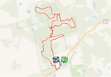
Trail Walking of 13.7 km to be discovered at Ontario, Dufferin County, Mono. This trail is proposed by Alizée.pee.

Description

Randonnée avec de belles forêts et des sentiers bien marqués. Il y a la possibilité d'adapter votre randonnée à tout moment selon vos envies. Une partie du sentier appartient au bien connu sentier Bruce. Sentier splendide.

Elevation profile

Positioning

Country:
Canada
Region :
Ontario
Department/Province :
Dufferin County
Municipality :
Mono
Location:
Unknown
Start:(UTM)
575711 ; 4869261 (17T) N.

Trails nearby

Trail Walking Mono - Wikiloc - Mono Cliffs Provincial Park - South Outlier - Photo
Walking
GUIDE
Alizée.pee

Walking

Medium
Mono, Ontario, Dufferin County, Canada
9.6 km | 12.3 km-effort
2h 38min
Yes


Close
My subscriptions