


liry

lousim22
User
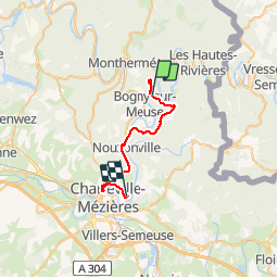

Length
23 km

Max alt
394 m

Uphill gradient
363 m
Km-Effort
29 km

Min alt
138 m

Downhill gradient
503 m
Boucle
No
Creation date :
2019-08-26 11:57:10.962
Updated on :
2019-08-26 14:11:24.743
2h12
Difficulty : Very easy

FREE GPS app for hiking
 SityTrail
IGN / Geographical institutes
SityTrail Plus
The world is yours!
About
Trail Walking of 23 km to be discovered at Grand Est, Ardennes, Bogny-sur-Meuse. This trail is proposed by lousim22.
Positioning
Country:
France
Region :
Grand Est
Department/Province :
Ardennes
Municipality :
Bogny-sur-Meuse
Location:
Unknown
Start:(Dec)
Start:(UTM)
627776 ; 5524308 (31U) N.
Comments