


canoé 1 belambra

philbea31
User

Length
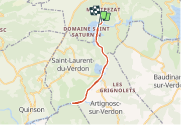
11.5 km

Max alt
432 m

Uphill gradient
129 m
Km-Effort
13.2 km

Min alt
401 m

Downhill gradient
125 m
Boucle
No
Creation date :
2019-08-26 07:22:27.695
Updated on :
2019-08-26 16:02:18.558
2h51
Difficulty : Easy

FREE GPS app for hiking
 SityTrail
IGN / Geographical institutes
SityTrail Plus
The world is yours!
About
Trail Canoe - kayak of 11.5 km to be discovered at Provence-Alpes-Côte d'Azur, Alpes-de-Haute-Provence, Montagnac-Montpezat. This trail is proposed by philbea31.
Photos


Positioning
Country:
France
Region :
Provence-Alpes-Côte d'Azur
Department/Province :
Alpes-de-Haute-Provence
Municipality :
Montagnac-Montpezat
Location:
Montpezat
Start:(Dec)
Start:(UTM)
265323 ; 4847436 (32T) N.
Comments