


randogps49-263

bubuserge
User
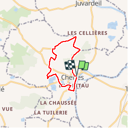

Length
9.4 km

Max alt
53 m

Uphill gradient
79 m
Km-Effort
10.5 km

Min alt
16 m

Downhill gradient
80 m
Boucle
Yes
Creation date :
2019-08-26 19:05:43.94
Updated on :
2019-09-27 19:26:22.546
2h19
Difficulty : Medium

FREE GPS app for hiking
 SityTrail
IGN / Geographical institutes
SityTrail Plus
The world is yours!
About
Trail Walking of 9.4 km to be discovered at Pays de la Loire, Maine-et-Loire, Cheffes. This trail is proposed by bubuserge.
Positioning
Country:
France
Region :
Pays de la Loire
Department/Province :
Maine-et-Loire
Municipality :
Cheffes
Location:
Unknown
Start:(Dec)
Start:(UTM)
687308 ; 5277183 (30T) N.
Comments