


poey-mayou 2019 fait

LouisROGER
User GUIDE
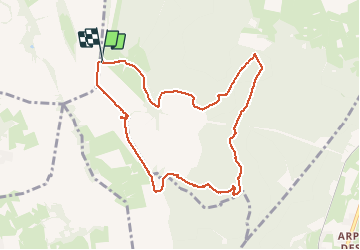

Length
9.7 km

Max alt
545 m

Uphill gradient
225 m
Km-Effort
12.7 km

Min alt
395 m

Downhill gradient
226 m
Boucle
Yes
Creation date :
2019-08-28 07:00:12.653
Updated on :
2019-08-28 09:58:10.077
2h56
Difficulty : Very easy

FREE GPS app for hiking
 SityTrail
IGN / Geographical institutes
SityTrail Plus
The world is yours!
About
Trail Walking of 9.7 km to be discovered at Occitania, Hautespyrenees, Ossun. This trail is proposed by LouisROGER.
Positioning
Country:
France
Region :
Occitania
Department/Province :
Hautespyrenees
Municipality :
Ossun
Location:
Unknown
Start:(Dec)
Start:(UTM)
738226 ; 4783105 (30T) N.
Comments