


20190830Moracey

Jeanclaudebic
User
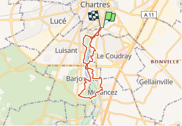

Length
12.6 km

Max alt
153 m

Uphill gradient
107 m
Km-Effort
14 km

Min alt
125 m

Downhill gradient
110 m
Boucle
Yes
Creation date :
2019-08-30 06:21:30.989
Updated on :
2019-08-30 08:48:32.143
2h26
Difficulty : Very easy

FREE GPS app for hiking
 SityTrail
IGN / Geographical institutes
SityTrail Plus
The world is yours!
About
Trail Walking of 12.6 km to be discovered at Centre-Loire Valley, Eure-et-Loir, Chartres. This trail is proposed by Jeanclaudebic.
Positioning
Country:
France
Region :
Centre-Loire Valley
Department/Province :
Eure-et-Loir
Municipality :
Chartres
Location:
Unknown
Start:(Dec)
Start:(UTM)
388598 ; 5365529 (31U) N.
Comments