


Papelissier

meillon
User
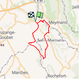

Length
11.5 km

Max alt
362 m

Uphill gradient
210 m
Km-Effort
14.3 km

Min alt
210 m

Downhill gradient
209 m
Boucle
Yes
Creation date :
2019-08-30 08:55:35.802
Updated on :
2019-08-30 13:20:37.434
4h23
Difficulty : Easy

FREE GPS app for hiking
 SityTrail
IGN / Geographical institutes
SityTrail Plus
The world is yours!
About
Trail Walking of 11.5 km to be discovered at Auvergne-Rhône-Alpes, Drôme, Chatuzange-le-Goubet. This trail is proposed by meillon.
Description
Promenade dans les champs et vers les rus de Fleurs et la Beaure...très agréable mais en été emmener de l eau fraiche
Photos


Positioning
Country:
France
Region :
Auvergne-Rhône-Alpes
Department/Province :
Drôme
Municipality :
Chatuzange-le-Goubet
Location:
Unknown
Start:(Dec)
Start:(UTM)
667511 ; 4986941 (31T) N.
Comments