


GR_347_AE_05_St-Servant_Josselin_20190830

patrickdanilo
User
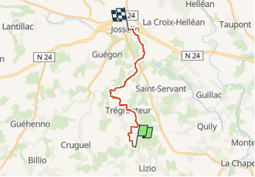

Length
14.4 km

Max alt
146 m

Uphill gradient
178 m
Km-Effort
17.1 km

Min alt
28 m

Downhill gradient
269 m
Boucle
No
Creation date :
2019-08-30 12:18:47.947
Updated on :
2022-12-14 13:40:42.826
3h31
Difficulty : Easy

FREE GPS app for hiking
 SityTrail
IGN / Geographical institutes
SityTrail Plus
The world is yours!
About
Trail Walking of 14.4 km to be discovered at Brittany, Morbihan, Saint-Servant. This trail is proposed by patrickdanilo.
Description
Randonnée Marche de 14,4 km à découvrir à Bretagne, Morbihan, Saint-Servant. Cette randonnée est proposée par patrickdanilo.
Photos


Positioning
Country:
France
Region :
Brittany
Department/Province :
Morbihan
Municipality :
Saint-Servant
Location:
Unknown
Start:(Dec)
Start:(UTM)
534610 ; 5302703 (30T) N.
Comments