
pierre a mata

JamesVautier
User

Length
12.6 km

Max alt
859 m

Uphill gradient
389 m
Km-Effort
17.8 km

Min alt
584 m

Downhill gradient
393 m
Boucle
Yes
Creation date :
2019-08-30 07:43:54.496
Updated on :
2019-08-30 17:23:44.392
4h58
Difficulty : Very easy

FREE GPS app for hiking
 SityTrail
IGN / Geographical institutes
SityTrail Plus
The world is yours!
About
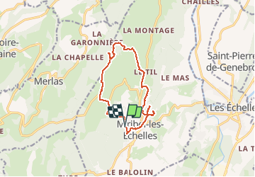
Trail Walking of 12.6 km to be discovered at Auvergne-Rhône-Alpes, Isère, Miribel-les-Échelles. This trail is proposed by JamesVautier.
Photos


Positioning
Country:
France
Region :
Auvergne-Rhône-Alpes
Department/Province :
Isère
Municipality :
Miribel-les-Échelles
Location:
Unknown
Start:(Dec)
Start:(UTM)
711295 ; 5034194 (31T) N.
Comments