


sy cretes

Steinier
User
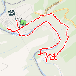

Length
6.2 km

Max alt
229 m

Uphill gradient
167 m
Km-Effort
8.4 km

Min alt
120 m

Downhill gradient
167 m
Boucle
No
Creation date :
2019-08-31 11:07:59.616
Updated on :
2019-08-31 16:24:14.415
1h36
Difficulty : Very easy

FREE GPS app for hiking
 SityTrail
IGN / Geographical institutes
SityTrail Plus
The world is yours!
About
Trail Walking of 6.2 km to be discovered at Wallonia, Liège, Ferrières. This trail is proposed by Steinier.
Positioning
Country:
Belgium
Region :
Wallonia
Department/Province :
Liège
Municipality :
Ferrières
Location:
Vieuxville
Start:(Dec)
Start:(UTM)
679428 ; 5586457 (31U) N.
Comments
ok