


GR34-EtapeII-J03

JMCMoreau
User
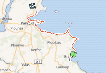

Length
24 km

Max alt
75 m

Uphill gradient
432 m
Km-Effort
30 km

Min alt
0 m

Downhill gradient
469 m
Boucle
No
Creation date :
2019-08-31 16:31:49.099
Updated on :
2023-01-21 17:31:47.37
9h00
Difficulty : Difficult

FREE GPS app for hiking
 SityTrail
IGN / Geographical institutes
SityTrail Plus
The world is yours!
About
Trail Walking of 24 km to be discovered at Brittany, Côtes-d'Armor, Plouha. This trail is proposed by JMCMoreau.
Description
Depuis le Parking du camping "Les Tamaris" de Bréhec - jusqu'au carrefour du calvaire de Ploubazlanec.
Positioning
Country:
France
Region :
Brittany
Department/Province :
Côtes-d'Armor
Municipality :
Plouha
Location:
Unknown
Start:(Dec)
Start:(UTM)
503616 ; 5396428 (30U) N.
Comments