


VTT Abreshwiller 01/09/19 circuit N° 1 avec Fabrice

vathi54
User
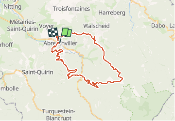


3h27
Difficulty : Difficult

FREE GPS app for hiking
 SityTrail
IGN / Geographical institutes
SityTrail Plus
The world is yours!
About
Trail Mountain bike of 33 km to be discovered at Grand Est, Moselle, Abreschviller. This trail is proposed by vathi54.
Description
Début de la rando sympa avec montée dans des singles mais beaucoup trop de descente sur des pistes forestières sans intérêt. Pas de vue sur les crêtes. On a du changer de parcours sur la fin pour retrouver des desentes en singles.
Photos


Positioning
Comments