


Clai Supérieur Loulou

newman
User
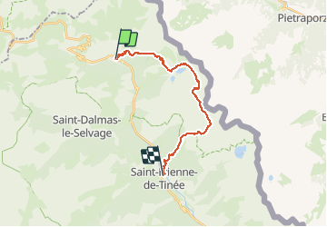

Length
21 km

Max alt
2959 m

Uphill gradient
1447 m
Km-Effort
42 km

Min alt
1143 m

Downhill gradient
1961 m
Boucle
No
Creation date :
2019-09-01 05:33:44.299
Updated on :
2019-09-01 14:19:50.852
8h42
Difficulty : Very easy

FREE GPS app for hiking
 SityTrail
IGN / Geographical institutes
SityTrail Plus
The world is yours!
About
Trail Walking of 21 km to be discovered at Provence-Alpes-Côte d'Azur, Maritime Alps, Saint-Étienne-de-Tinée. This trail is proposed by newman.
Positioning
Country:
France
Region :
Provence-Alpes-Côte d'Azur
Department/Province :
Maritime Alps
Municipality :
Saint-Étienne-de-Tinée
Location:
Unknown
Start:(Dec)
Start:(UTM)
331607 ; 4909733 (32T) N.
Comments