


forestière de leyment

lemarinelr
User
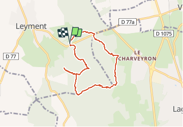

Length
7.2 km

Max alt
309 m

Uphill gradient
87 m
Km-Effort
8.4 km

Min alt
269 m

Downhill gradient
86 m
Boucle
Yes
Creation date :
2019-09-01 13:04:51.029
Updated on :
2019-09-01 15:15:32.002
1h45
Difficulty : Very easy

FREE GPS app for hiking
 SityTrail
IGN / Geographical institutes
SityTrail Plus
The world is yours!
About
Trail Walking of 7.2 km to be discovered at Auvergne-Rhône-Alpes, Ain, Leyment. This trail is proposed by lemarinelr.
Positioning
Country:
France
Region :
Auvergne-Rhône-Alpes
Department/Province :
Ain
Municipality :
Leyment
Location:
Unknown
Start:(Dec)
Start:(UTM)
679014 ; 5087633 (31T) N.
Comments