


Belledonne Jour 1

CASSISFRAMBOISE
User

Length
2.8 km

Max alt
1847 m

Uphill gradient
204 m
Km-Effort
5.2 km

Min alt
1644 m

Downhill gradient
111 m
Boucle
No
Creation date :
2019-09-01 12:25:58.723
Updated on :
2019-09-02 14:30:28.224
1h13
Difficulty : Very easy

FREE GPS app for hiking
 SityTrail
IGN / Geographical institutes
SityTrail Plus
The world is yours!
About
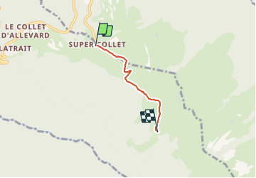
Trail Walking of 2.8 km to be discovered at Auvergne-Rhône-Alpes, Isère, Allevard. This trail is proposed by CASSISFRAMBOISE.
Positioning
Country:
France
Region :
Auvergne-Rhône-Alpes
Department/Province :
Isère
Municipality :
Allevard
Location:
Unknown
Start:(Dec)
Start:(UTM)
275200 ; 5030641 (32T) N.
Comments