


belledonne j2

CASSISFRAMBOISE
User
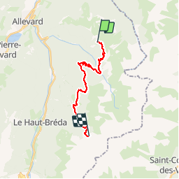

Length
16.5 km

Max alt
1824 m

Uphill gradient
1270 m
Km-Effort
33 km

Min alt
1095 m

Downhill gradient
1193 m
Boucle
No
Creation date :
2019-09-02 05:10:59.974
Updated on :
2019-09-02 14:34:15.671
8h20
Difficulty : Very difficult

FREE GPS app for hiking
 SityTrail
IGN / Geographical institutes
SityTrail Plus
The world is yours!
About
Trail Walking of 16.5 km to be discovered at Auvergne-Rhône-Alpes, Isère, Allevard. This trail is proposed by CASSISFRAMBOISE.
Positioning
Country:
France
Region :
Auvergne-Rhône-Alpes
Department/Province :
Isère
Municipality :
Allevard
Location:
Unknown
Start:(Dec)
Start:(UTM)
276330 ; 5028985 (32T) N.
Comments