


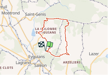
Crête de St Genis

RobinMicheline
User GUIDE

Length
13.6 km

Max alt
1194 m

Uphill gradient
723 m
Km-Effort
23 km

Min alt
651 m

Downhill gradient
722 m
Boucle
Yes
Creation date :
2019-09-02 15:46:53.708
Updated on :
2020-06-29 18:41:25.54
--
Difficulty : Very easy

FREE GPS app for hiking
 SityTrail
IGN / Geographical institutes
SityTrail Plus
The world is yours!
About
Trail On foot of 13.6 km to be discovered at Provence-Alpes-Côte d'Azur, Hautes-Alpes, Garde-Colombe. This trail is proposed by RobinMicheline.
Description
Belle rando , sentiers sympas , un petit peu d escalade , belle vue sur les cretes , sentier glissant descente
Positioning
Country:
France
Region :
Provence-Alpes-Côte d'Azur
Department/Province :
Hautes-Alpes
Municipality :
Garde-Colombe
Location:
Unknown
Start:(Dec)
Start:(UTM)
721742 ; 4914577 (31T) N.
Comments