


Locronan - 2.2km 20m 45mn - 2019 09 02

Orcal37
User GUIDE
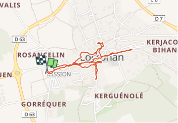

Length
2.2 km

Max alt
163 m

Uphill gradient
22 m
Km-Effort
2.5 km

Min alt
146 m

Downhill gradient
24 m
Boucle
Yes
Creation date :
2019-09-02 09:36:02.242
Updated on :
2021-09-08 16:06:13.06
45m
Difficulty : Very easy

FREE GPS app for hiking
 SityTrail
IGN / Geographical institutes
SityTrail Plus
The world is yours!
About
Trail Walking of 2.2 km to be discovered at Brittany, Finistère, Locronan. This trail is proposed by Orcal37.
Description
Locronan - 2.2km 20m 45mn - 2019 09 02
Photos


Positioning
Country:
France
Region :
Brittany
Department/Province :
Finistère
Municipality :
Locronan
Location:
Unknown
Start:(Dec)
Start:(UTM)
409721 ; 5327847 (30U) N.
Comments
dimanche 14/05/23 pour ALBG