Trail Walking Mont-Élie - ACTIVE LOG091154 - Photo
 Alizée.pee
Alizée.pee

User GUIDE

© OpenStreetMap contributors
Length
Length
10.5 km
Max alt
Max alt
1041 m
Uphill gradient
Uphill gradient
860 m
Km-Effort
Km-Effort  
22 km
Min alt
Min alt
258 m
Downhill gradient
Downhill gradient
861 m
Boucle
Boucle
Yes
Creation date :
2019-09-03 10:38:59.964
Updated on :
2019-09-03 10:40:09.536

(0 Reviews)

Walking
Walking
5h00
Difficulty : Very difficult

Scan this QR Code to open this trail in the SityTrail application

FREE GPS app for hiking

Logo SityTrail SityTrail

IGN / Geographical institutes

Download SityTrail from the App Store Download SityTrail from Google Play

Logo SityTrail SityTrail World

The world is yours!

Download SityTrail from the App Store Download SityTrail from Google Play Download SityTrail on Huawei AppGallery

About

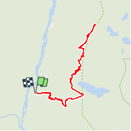
Trail Walking of 10.5 km to be discovered at Quebec, Charlevoix-Est, Mont-Élie. This trail is proposed by Alizée.pee.

Description

Incontournable du Québec se situant dans le parc des Hautes-Gorges-de-la-Rivière-Malbaie avec une vue plongeante sur la rivière Malbaie. On peut admirer les plus hautes parois rocheuses de l’Est du Canada. Le paysage est à couper le souffle. Néanmoins, le sentier pour arriver jusqu’au sommet est assez difficile du au fort dénivelé sur un sentier assez court. Randonnée à effectuer absolument afin d’avoir des étoiles dans les yeux. L’effort en vaut la peine ! Pour arriver au début du sentier, il faut penser à prendre une navette. N’hésitez pas à vous renseigner sur les horaires des navettes et du parc.

Elevation profile

Positioning

Country:
Canada
Region :
Quebec
Department/Province :
Charlevoix-Est
Municipality :
Mont-Élie
Location:
Unknown
Start:(UTM)
389245 ; 5303640 (19T) N.

Trails nearby

Trail Walking Mont-Élie - Trail Planner Map - Photo
Walking
GUIDE
Alizée.pee

Walking

Difficult
Mont-Élie, Quebec, Charlevoix-Est, Canada
21 km | 28 km-effort
5h 57min
Yes
Trail Walking Mont-Élie - Wikiloc - Charlevoix- Haute Gorges - Acropole des Draveurs - Photo
Walking
GUIDE
Alizée.pee

Walking

Difficult
Mont-Élie, Quebec, Charlevoix-Est, Canada
10.1 km | 22 km-effort
4h 17min
Yes
Trail Walking Mont-Élie - Wikiloc - Parc des Hautes Gorges de la riviere Malbaie. L' acropole des draveurs. - Photo
Walking
GUIDE
Alizée.pee

Walking

Very difficult
Mont-Élie, Quebec, Charlevoix-Est, Canada
10.7 km | 22 km-effort
4h 25min
Yes
Trail Walking Mont-Élie - les rapides de la Malbaie - Photo
Walking
aldaus

Walking

Medium
Mont-Élie, Quebec, Charlevoix-Est, Canada
9.5 km | 10.8 km-effort
2h 45min
No
Trail Walking Mont-Élie - lac sans oreilles - Photo
Walking
aldaus

Walking

Medium
Mont-Élie, Quebec, Charlevoix-Est, Canada
7.7 km | 11.1 km-effort
1h 57min
Yes


Close
My subscriptions