


entrevennes par les maisons

lecmic
User
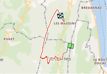

Length
6.6 km

Max alt
1324 m

Uphill gradient
547 m
Km-Effort
14.3 km

Min alt
665 m

Downhill gradient
671 m
Boucle
No
Creation date :
2019-09-03 07:53:54.448
Updated on :
2019-09-03 10:52:39.594
2h49
Difficulty : Very easy

FREE GPS app for hiking
 SityTrail
IGN / Geographical institutes
SityTrail Plus
The world is yours!
About
Trail Walking of 6.6 km to be discovered at Auvergne-Rhône-Alpes, Upper Savoy, Entrevernes. This trail is proposed by lecmic.
Description
rando sur sentier a la montée,point de vue au sommet,et descente raide. jusqu'au maisons.
Positioning
Country:
France
Region :
Auvergne-Rhône-Alpes
Department/Province :
Upper Savoy
Municipality :
Entrevernes
Location:
Unknown
Start:(Dec)
Start:(UTM)
281917 ; 5075518 (32T) N.
Comments