


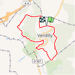
Verdilly ADR

VANDERPUTTENMi
User GUIDE

Length
7.4 km

Max alt
219 m

Uphill gradient
173 m
Km-Effort
9.7 km

Min alt
103 m

Downhill gradient
171 m
Boucle
Yes
Creation date :
2019-09-03 11:40:24.78
Updated on :
2019-09-03 15:27:32.433
2h28
Difficulty : Easy

FREE GPS app for hiking
 SityTrail
IGN / Geographical institutes
SityTrail Plus
The world is yours!
About
Trail Walking of 7.4 km to be discovered at Hauts-de-France, Aisne, Verdilly. This trail is proposed by VANDERPUTTENMi.
Description
Randonnée avec de beaux points de vues....
Positioning
Country:
France
Region :
Hauts-de-France
Department/Province :
Aisne
Municipality :
Verdilly
Location:
Unknown
Start:(Dec)
Start:(UTM)
531089 ; 5436084 (31U) N.
Comments