


Lake Taggart et Bradley - Grand Tetons

GOHIER
User
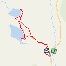

Length
9.2 km

Max alt
2184 m

Uphill gradient
217 m
Km-Effort
12.1 km

Min alt
2019 m

Downhill gradient
217 m
Boucle
Yes
Creation date :
2019-09-03 17:27:28.0
Updated on :
2019-09-15 07:16:45.95
5h37
Difficulty : Unknown

FREE GPS app for hiking
 SityTrail
IGN / Geographical institutes
SityTrail Plus
The world is yours!
About
Trail Walking of 9.2 km to be discovered at Wyoming, Teton County. This trail is proposed by GOHIER.
Description
3 beaux lacs, des canards et presque un(e) ours(e)!
Photos

Positioning
Country:
United States
Region :
Wyoming
Department/Province :
Teton County
Municipality :
Taggart Creek
Location:
Unknown
Start:(Dec)
Start:(UTM)
521540 ; 4837798 (12T) N.
Comments