


tour du lac d'Aydat

walrou63
User
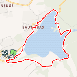

Length
5.5 km

Max alt
880 m

Uphill gradient
74 m
Km-Effort
6.5 km

Min alt
838 m

Downhill gradient
76 m
Boucle
Yes
Creation date :
2019-09-04 12:14:32.739
Updated on :
2019-09-04 15:15:18.059
2h00
Difficulty : Very easy

FREE GPS app for hiking
 SityTrail
IGN / Geographical institutes
SityTrail Plus
The world is yours!
About
Trail Walking of 5.5 km to be discovered at Auvergne-Rhône-Alpes, Puy-de-Dôme, Aydat. This trail is proposed by walrou63.
Photos


Positioning
Country:
France
Region :
Auvergne-Rhône-Alpes
Department/Province :
Puy-de-Dôme
Municipality :
Aydat
Location:
Unknown
Start:(Dec)
Start:(UTM)
498085 ; 5056304 (31T) N.
Comments