


lac lignin

CLP01
User
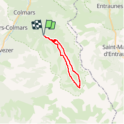

Length
17.6 km

Max alt
2289 m

Uphill gradient
713 m
Km-Effort
27 km

Min alt
1641 m

Downhill gradient
727 m
Boucle
Yes
Creation date :
2019-09-05 06:26:22.323
Updated on :
2019-09-05 16:23:53.407
4h42
Difficulty : Medium

FREE GPS app for hiking
 SityTrail
IGN / Geographical institutes
SityTrail Plus
The world is yours!
About
Trail Walking of 17.6 km to be discovered at Provence-Alpes-Côte d'Azur, Alpes-de-Haute-Provence, Colmars. This trail is proposed by CLP01.
Positioning
Country:
France
Region :
Provence-Alpes-Côte d'Azur
Department/Province :
Alpes-de-Haute-Provence
Municipality :
Colmars
Location:
Unknown
Start:(Dec)
Start:(UTM)
312476 ; 4892048 (32T) N.
Comments