


Editing in english !

Doubotis
User ADMIN
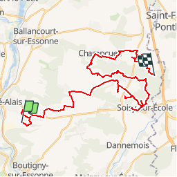

Length
41 km

Max alt
149 m

Uphill gradient
453 m
Km-Effort
47 km

Min alt
71 m

Downhill gradient
442 m
Boucle
No
Creation date :
2019-09-06 08:34:55.982
Updated on :
2019-10-07 11:21:11.893
20m
Difficulty : Easy

FREE GPS app for hiking
 SityTrail
IGN / Geographical institutes
SityTrail Plus
The world is yours!
About
Trail Trail of 41 km to be discovered at Ile-de-France, Essonne, Guigneville-sur-Essonne. This trail is proposed by Doubotis.
Description
efezfzfe
Positioning
Country:
France
Region :
Ile-de-France
Department/Province :
Essonne
Municipality :
Guigneville-sur-Essonne
Location:
Unknown
Start:(Dec)
Start:(UTM)
453582 ; 5368626 (31U) N.
Comments