Trail Road bike L'Isle-aux-Coudres - Trail Planner Map - Photo
 Alizée.pee
Alizée.pee

User GUIDE

© OpenStreetMap contributors
Length
Length
24 km
Max alt
Max alt
82 m
Uphill gradient
Uphill gradient
246 m
Km-Effort
Km-Effort  
28 km
Min alt
Min alt
-1 m
Downhill gradient
Downhill gradient
246 m
Boucle
Boucle
Yes
Creation date :
2019-09-06 08:40:51.742
Updated on :
2019-09-06 08:55:28.406

(0 Reviews)

Road bike
Road bike
1h37
Difficulty : Medium

Scan this QR Code to open this trail in the SityTrail application

FREE GPS app for hiking

Logo SityTrail SityTrail

IGN / Geographical institutes

Download SityTrail from the App Store Download SityTrail from Google Play

Logo SityTrail SityTrail World

The world is yours!

Download SityTrail from the App Store Download SityTrail from Google Play Download SityTrail on Huawei AppGallery

About

Trail Road bike of 24 km to be discovered at Quebec, Charlevoix, L'Isle-aux-Coudres. This trail is proposed by Alizée.pee.

Description

Randonnée cycliste pour tous les nivaux de compétence. Le sentier est très agréable et offre de nombreuses vues panoramiques. Très agréable pour découvrir cette jolie petite île.

Elevation profile

Positioning

Country:
Canada
Region :
Quebec
Department/Province :
Charlevoix
Municipality :
L'Isle-aux-Coudres
Location:
Unknown
Start:(UTM)
395070 ; 5252830 (19T) N.

Trails nearby

Trail Walking Petite-Rivière-Saint-François - Gabrielle-Roy EST - Photo
Walking
Tommy Blackburn

Walking

Difficult
(1)
Petite-Rivière-Saint-François, Quebec, Charlevoix, Canada
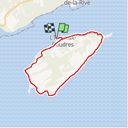
12.1 km | 19.5 km-effort
4h 42min
Yes
Trail Walking Baie-Saint-Paul - Rando Baie-Saint-Paul Québec - Photo
Walking
TRIMAILLE

Walking

Easy
Baie-Saint-Paul, Quebec, Charlevoix, Canada
3 km | 3.3 km-effort
43min
No


Close
My subscriptions