


Avallon...

VANDERPUTTENMi
User GUIDE
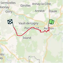

Length
13.1 km

Max alt
265 m

Uphill gradient
192 m
Km-Effort
15.8 km

Min alt
155 m

Downhill gradient
233 m
Boucle
No
Creation date :
2019-09-06 08:23:32.42
Updated on :
2019-09-06 12:05:30.269
2h57
Difficulty : Very easy

FREE GPS app for hiking
 SityTrail
IGN / Geographical institutes
SityTrail Plus
The world is yours!
About
Trail Walking of 13.1 km to be discovered at Bourgogne-Franche-Comté, Yonne, Avallon. This trail is proposed by VANDERPUTTENMi.
Positioning
Country:
France
Region :
Bourgogne-Franche-Comté
Department/Province :
Yonne
Municipality :
Avallon
Location:
Unknown
Start:(Dec)
Start:(UTM)
568172 ; 5259989 (31T) N.
Comments