


Luskville Falls Trail

Alizée.pee
User GUIDE
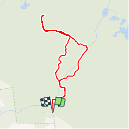


1h35
Difficulty : Medium

FREE GPS app for hiking
 SityTrail
IGN / Geographical institutes
SityTrail World
The world is yours!
About
Trail Walking of 4 km to be discovered at Quebec, Les Collines-de-l'Outaouais, Pontiac. This trail is proposed by Alizée.pee.
Description
randonnée qui mène à un sommet offrant des vues magnifiques sur la vallée de la rivière des Outaouais. Sur le sentier, les plantes et les arbres vont vous éblouir et vous allez découvrir l’écosystème le plus spectaculaire du parc de la Gatineau. Vous y verrez une belle cascade si celle-ci n’est pas asséchée. Malgré la montée assez raide, la vue en vaut la peine.


Positioning
Comments
Trails nearby