Trail Walking Sainte-Lucie-des-Laurentides - Trail Planner Map - Photo
 Alizée.pee
Alizée.pee

User GUIDE

© OpenStreetMap contributors
Length
Length
5.8 km
Max alt
Max alt
827 m
Uphill gradient
Uphill gradient
357 m
Km-Effort
Km-Effort  
10.6 km
Min alt
Min alt
483 m
Downhill gradient
Downhill gradient
357 m
Boucle
Boucle
Yes
Creation date :
2019-09-06 12:50:16.149
Updated on :
2019-09-06 12:50:54.346

(0 Reviews)

Walking
Walking
2h07
Difficulty : Medium

Scan this QR Code to open this trail in the SityTrail application

FREE GPS app for hiking

Logo SityTrail SityTrail

IGN / Geographical institutes

Download SityTrail from the App Store Download SityTrail from Google Play

Logo SityTrail SityTrail Plus

The world is yours!

Download SityTrail from the App Store Download SityTrail from Google Play Download SityTrail on Huawei AppGallery

About

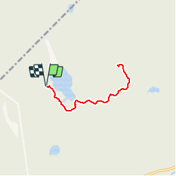
Trail Walking of 5.8 km to be discovered at Quebec, Les Laurentides, Sainte-Lucie-des-Laurentides. This trail is proposed by Alizée.pee.

Description

Le sentier du Mont Kaaikop se situe près de Sainte-Lucie-Des-Laurentides. La randonnée est magnifique, avec une montée dès le début du sentier, avec un beau point de vue au sommet. Elle est assez courte mais possède de magnifiques paysages.

Elevation profile

Positioning

Country:
Canada
Region :
Quebec
Department/Province :
Les Laurentides
Municipality :
Sainte-Lucie-des-Laurentides
Location:
Unknown
Start:(UTM)
561133 ; 5119290 (18T) N.


Close
My subscriptions