


Saint-Claude Flumen Septmoncel fait

pidjam
User
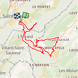

Length
20 km

Max alt
1027 m

Uphill gradient
816 m
Km-Effort
31 km

Min alt
398 m

Downhill gradient
816 m
Boucle
Yes
Creation date :
2019-09-06 07:20:42.236
Updated on :
2019-09-06 13:48:41.909
6h02
Difficulty : Difficult

FREE GPS app for hiking
 SityTrail
IGN / Geographical institutes
SityTrail Plus
The world is yours!
About
Trail Walking of 20 km to be discovered at Bourgogne-Franche-Comté, Jura, Saint-Claude. This trail is proposed by pidjam.
Positioning
Country:
France
Region :
Bourgogne-Franche-Comté
Department/Province :
Jura
Municipality :
Saint-Claude
Location:
Unknown
Start:(Dec)
Start:(UTM)
720702 ; 5140608 (31T) N.
Comments