


Dt de Morcles

tigrouu
User


--
Difficulty : Unknown

FREE GPS app for hiking
 SityTrail
IGN / Geographical institutes
SityTrail Plus
The world is yours!
About
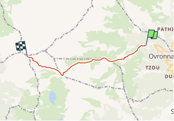
Trail Winter sports of 7.8 km to be discovered at Valais/Wallis, Martigny, Leytron. This trail is proposed by tigrouu.
Description
Départ de la station d''Ovronnaz, puis montée en direction du petit pré, de la poursuivre sur un léger plat en restant sur le flanc gauche de la montagne (grd-Chateau),montée sur le col de fenestral puis continuer jusqu''au sommet de la croix poursuivre sur l''arête et de là un portage des skis sur 50m est nécessaire, en haut du couloir on débouche sur la partie sommitale qui nous amène au sommet. Magnifique vue sur le bassin lémanique et sur toutes les Alpes.
Il faut compter env. 3h00 pour monter et env. 45 min pour la descente.
Positioning
Comments