


champsaur 2020 pic de queyrel départ chaillol 1600

gerardmicheline
User
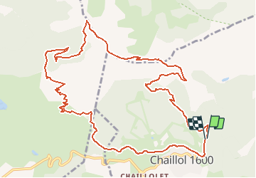

Length
14.4 km

Max alt
2425 m

Uphill gradient
915 m
Km-Effort
27 km

Min alt
1593 m

Downhill gradient
928 m
Boucle
Yes
Creation date :
2019-09-08 15:34:29.124
Updated on :
2020-07-26 08:43:11.557
5h19
Difficulty : Very difficult

FREE GPS app for hiking
 SityTrail
IGN / Geographical institutes
SityTrail Plus
The world is yours!
About
Trail Walking of 14.4 km to be discovered at Provence-Alpes-Côte d'Azur, Hautes-Alpes, Saint-Michel-de-Chaillol. This trail is proposed by gerardmicheline.
Positioning
Country:
France
Region :
Provence-Alpes-Côte d'Azur
Department/Province :
Hautes-Alpes
Municipality :
Saint-Michel-de-Chaillol
Location:
Unknown
Start:(Dec)
Start:(UTM)
275697 ; 4952635 (32T) N.
Comments