


Châtel Lac de la Mouille

drarep
User
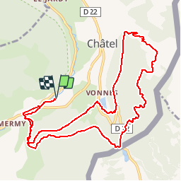

Length
12.6 km

Max alt
1694 m

Uphill gradient
775 m
Km-Effort
23 km

Min alt
1107 m

Downhill gradient
775 m
Boucle
Yes
Creation date :
2019-09-08 18:05:43.976
Updated on :
2019-09-08 18:06:29.052
4h36
Difficulty : Difficult

FREE GPS app for hiking
 SityTrail
IGN / Geographical institutes
SityTrail Plus
The world is yours!
About
Trail Walking of 12.6 km to be discovered at Auvergne-Rhône-Alpes, Upper Savoy, Châtel. This trail is proposed by drarep.
Positioning
Country:
France
Region :
Auvergne-Rhône-Alpes
Department/Province :
Upper Savoy
Municipality :
Châtel
Location:
Unknown
Start:(Dec)
Start:(UTM)
332769 ; 5124990 (32T) N.
Comments