


Seillac_lac Ste Anne

bernir
User
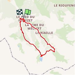

Length
14 km

Max alt
2414 m

Uphill gradient
822 m
Km-Effort
25 km

Min alt
1680 m

Downhill gradient
819 m
Boucle
Yes
Creation date :
2019-09-04 07:17:17.191
Updated on :
2019-09-09 13:41:44.223
7h13
Difficulty : Difficult

FREE GPS app for hiking
 SityTrail
IGN / Geographical institutes
SityTrail Plus
The world is yours!
About
Trail Walking of 14 km to be discovered at Provence-Alpes-Côte d'Azur, Hautes-Alpes, Ceillac. This trail is proposed by bernir.
Positioning
Country:
France
Region :
Provence-Alpes-Côte d'Azur
Department/Province :
Hautes-Alpes
Municipality :
Ceillac
Location:
Unknown
Start:(Dec)
Start:(UTM)
324848 ; 4946518 (32T) N.
Comments