


St Veran_refuge de la Blanche

bernir
User
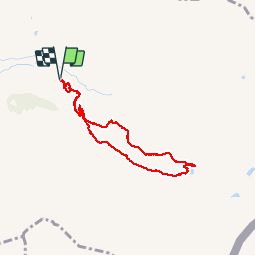

Length
6.7 km

Max alt
2510 m

Uphill gradient
216 m
Km-Effort
9.6 km

Min alt
2296 m

Downhill gradient
214 m
Boucle
Yes
Creation date :
2019-09-05 07:41:34.202
Updated on :
2019-09-09 13:48:36.317
4h04
Difficulty : Easy

FREE GPS app for hiking
 SityTrail
IGN / Geographical institutes
SityTrail Plus
The world is yours!
About
Trail Walking of 6.7 km to be discovered at Provence-Alpes-Côte d'Azur, Hautes-Alpes, Saint-Véran. This trail is proposed by bernir.
Positioning
Country:
France
Region :
Provence-Alpes-Côte d'Azur
Department/Province :
Hautes-Alpes
Municipality :
Saint-Véran
Location:
Unknown
Start:(Dec)
Start:(UTM)
335062 ; 4949170 (32T) N.
Comments