


jour 1 CAP Jeanot

jeannat
User
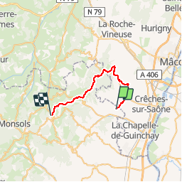

Length
26 km

Max alt
735 m

Uphill gradient
879 m
Km-Effort
38 km

Min alt
240 m

Downhill gradient
734 m
Boucle
No
Creation date :
2019-09-09 13:18:25.749
Updated on :
2019-09-24 09:21:47.391
3h41
Difficulty : Very easy

FREE GPS app for hiking
 SityTrail
IGN / Geographical institutes
SityTrail Plus
The world is yours!
About
Trail Running of 26 km to be discovered at Auvergne-Rhône-Alpes, Rhône, Juliénas. This trail is proposed by jeannat.
Description
De Julienas à Ouroux en passant par La roche de solutré
Photos


Positioning
Country:
France
Region :
Auvergne-Rhône-Alpes
Department/Province :
Rhône
Municipality :
Juliénas
Location:
Unknown
Start:(Dec)
Start:(UTM)
632464 ; 5122177 (31T) N.
Comments