


Châtel Les Mouets

drarep
User
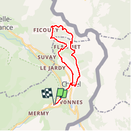

Length
13.4 km

Max alt
1759 m

Uphill gradient
729 m
Km-Effort
23 km

Min alt
1103 m

Downhill gradient
727 m
Boucle
Yes
Creation date :
2019-09-09 19:10:58.141
Updated on :
2019-09-09 19:11:38.908
4h41
Difficulty : Medium

FREE GPS app for hiking
 SityTrail
IGN / Geographical institutes
SityTrail Plus
The world is yours!
About
Trail Walking of 13.4 km to be discovered at Auvergne-Rhône-Alpes, Upper Savoy, Châtel. This trail is proposed by drarep.
Positioning
Country:
France
Region :
Auvergne-Rhône-Alpes
Department/Province :
Upper Savoy
Municipality :
Châtel
Location:
Unknown
Start:(Dec)
Start:(UTM)
332769 ; 5124997 (32T) N.
Comments