


Sommet du Javanon depart Lac du Riou

claude nier
User
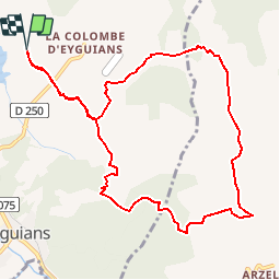

Length
11.1 km

Max alt
865 m

Uphill gradient
375 m
Km-Effort
16.1 km

Min alt
651 m

Downhill gradient
375 m
Boucle
Yes
Creation date :
2019-09-10 10:20:30.042
Updated on :
2019-09-10 10:21:59.337
--
Difficulty : Medium

FREE GPS app for hiking
 SityTrail
IGN / Geographical institutes
SityTrail Plus
The world is yours!
About
Trail On foot of 11.1 km to be discovered at Provence-Alpes-Côte d'Azur, Hautes-Alpes, Garde-Colombe. This trail is proposed by claude nier.
Description
belle rando
Positioning
Country:
France
Region :
Provence-Alpes-Côte d'Azur
Department/Province :
Hautes-Alpes
Municipality :
Garde-Colombe
Location:
Eyguians
Start:(Dec)
Start:(UTM)
720972 ; 4916353 (31T) N.
Comments